Department of Earth Sciences
Service Navigation
Noctis Labyrinthus Mosaic - The Truth Lies in the Details
Image data, taken by the High Resolution Stereo Camera (HRSC) on board ESA’s Mars Express mission were compiled to a mosaic to show the manifold details and their geological context in the region. HRSC is a camera experiment that was developed and is operated by the German Aerospace Center (Deutsches Zentrum für Luft- und Raumfahrt; DLR).
» read more in the main article below...
Noctis Labyrinthus Mosaic • Position & 3D view

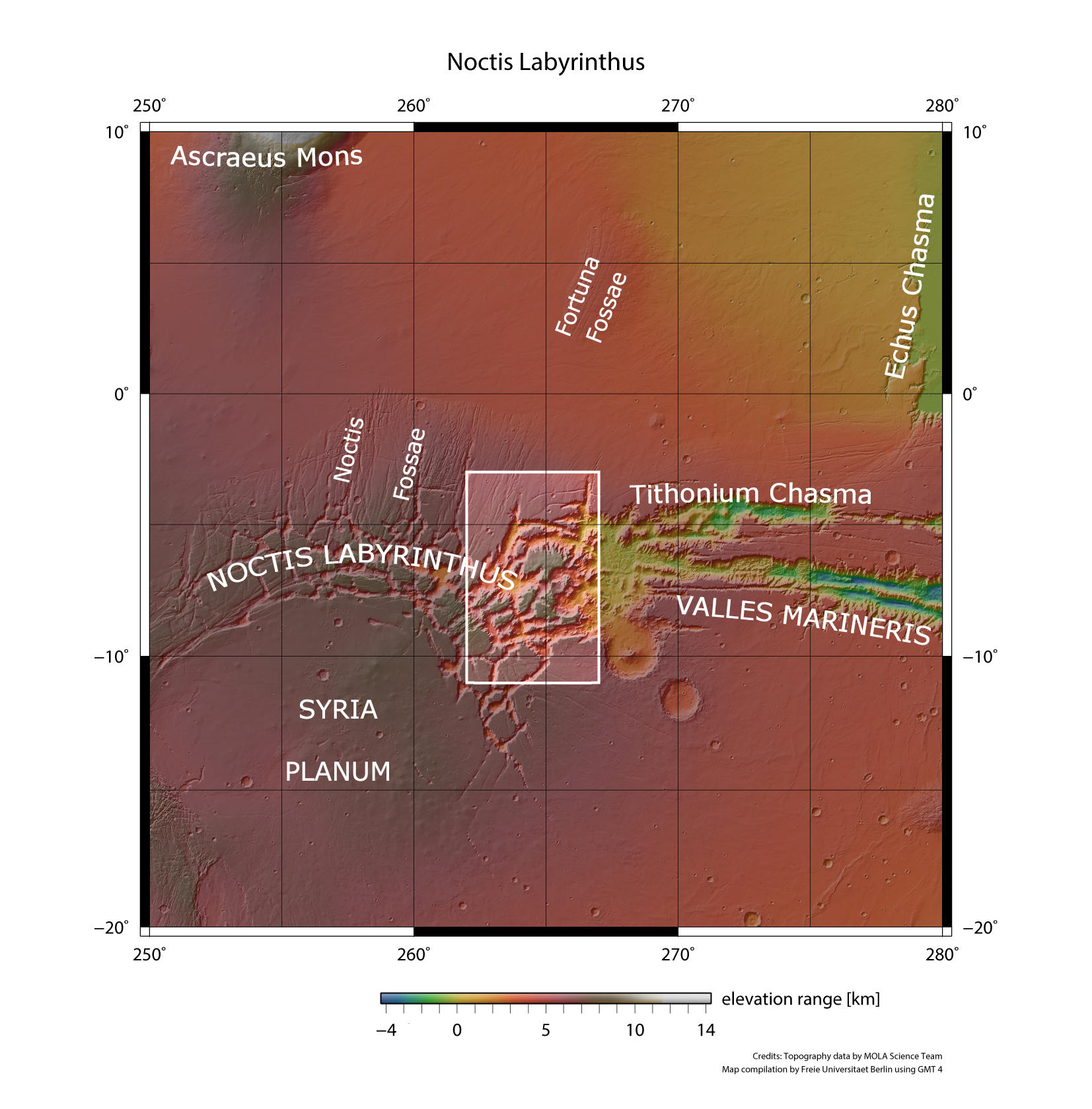
Noctis Labyrinthus Mosaic - context map
Image Credit: MOLA Science Team/FU Berlin

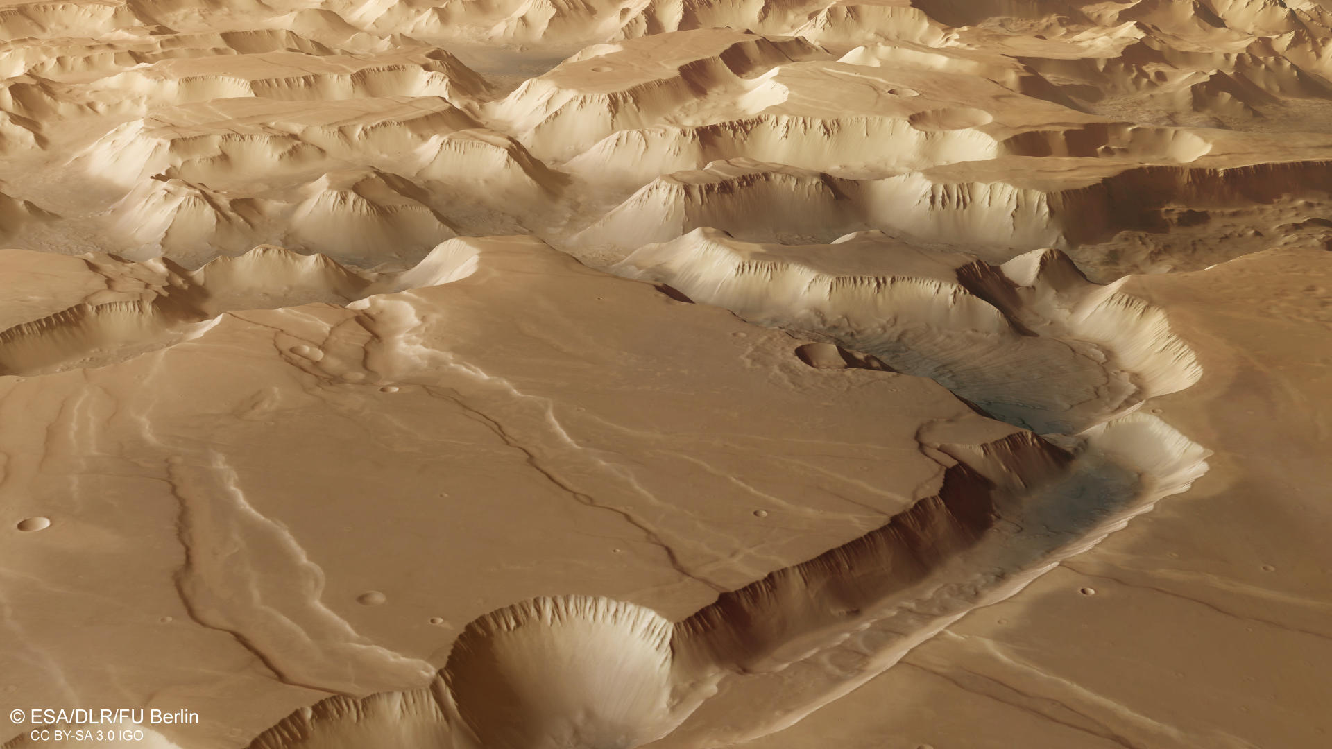
Noctis Labyrinthus Mosaic - 3D 1
Image Credit: ESA/DLR/FU Berlin

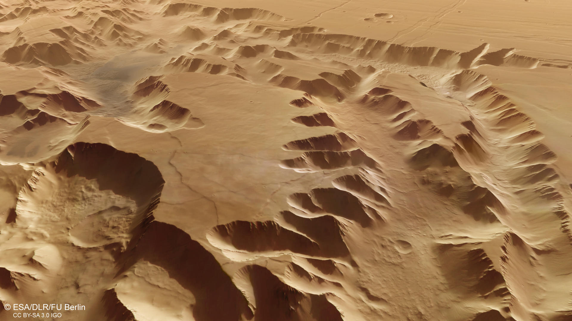
Noctis Labyrinthus - 3D 2
Image Credit: ESA/DLR/FU Berlin

Noctis Labyrinthus - HRSC "virtual" anaglph
Image Credit: ESA/DLR/FU Berlin
Noctis Labyrinthus Mosaic • HRSC images

Noctis Labyrinthus - color-coded terrain model
Image Credit: ESA/DLR/FU Berlin

Noctis Labyrinthus - HRSC color
Image Credit: ESA/DLR/FU Berlin

Noctis Labyrinthus Mosaic - HRSC annotated
Image Credit: ESA/DLR/FU Berlin
Noctis Labyrinthus Mosaic
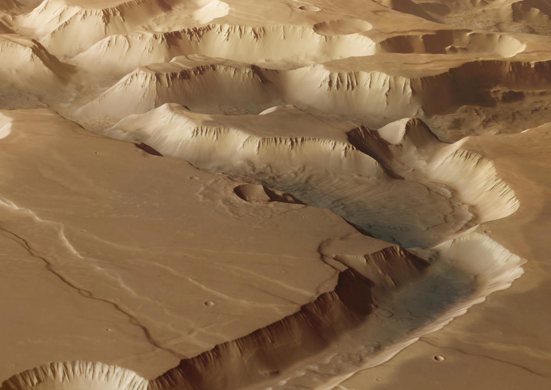
The Noctis Labyrinthus region (Latin for “labyrinth of night”) is located between the western edge of Valles Marineris and the Tharsis upland. It has a length of 1190 km and is characterized by a system of deep and steep-walled valleys formed by faulting. Many of the valleys show the classical appearance of so-called graben. A graben is a part of the crust that has subsided in relation to the blocks on either side. The faults typically dip toward the center of the graben from both sides. The fractures are witnesses of extensional tectonics. The intense volcanism in the Tharsis region was associated with an up-arching of large areas. This process resulted in tectonic stress, causing the crust to thin out and lead to the graben formation. Large plateaus representing the original surface level dominate the region. The intersecting canyons and valleys are up to 30 kilometers wide and up to six kilometers deep. There is no comparable landscape on Earth, nor on any other planet or moon in the Solar System. In many places, gigantic landslides can be found, covering the steep valley slopes and the valley floors. In other places, large linear structures can be found on the valley slopes. These structures are wind-blown sand deposits, accumulating to large dune fields. The alignment of the dune crests indicates that in some areas the sand was transported downslope, while in other places, the dune sand has been blown uphill.
Spectral investigations revealed layers of hydrated sulfates and clay minerals at the steep slopes. These minerals are indicative of aqueous environments in ancient times. It is very likely that Noctis Labyrinthus experienced an intense hydrological period when these rocks were formed. Elsewhere, long, extensively interconnected linear structures can be observed along the valley slopes. These are sand and dust deposits that have been shaped by wind into extensive ribbed fields whose ridges are separated by distances of 150 and 400 m. These sand ridges are oriented perpendicular to the wind direction and often formed on large bodies of sand or dune surfaces. The almost vertical orientation of the ridges on numerous slopes indicates that sand was transported parallel to the slope, while on the valley floors or on shallower slopes, the wind transported the fine-grained material from different directions along the valleys and also even uphill.
This mosaic consists of 8 HRSC images with a resolution of 12.5 m per pixel. In addition to the regular images, we also feature a downloadable GIS-ready digital terrain model (DTM) that can be used to further dive into this intriguing region of Mars. The anaglyph image is not as usual rendered with HRSC’s stereo channels, but instead by using the DTM information and the nadir mosaic to “virtually” generate an anaglyph. The annotated image shows the locations of interesting geological features. The mosaic is very large and contains many details that can only be seen by zooming deeply into the image.
High Resolution Stereo Camera (HRSC)
The mosaic is composed of 8 HRSC images (Orbits : 0442, 1085, 1944, 1977, 1988, 10497, 14632, 16684). The ground resolution is approximately 12.5 meter per pixel and the image is centered at about 265° East and 7° South. The color image was created using data from the nadir channel, the field of view which is aligned perpendicular to the surface of Mars, and the color channels of the HRSC. The oblique perspective view was generated from the digital terrain model, the nadir and color channels of HRSC. The anaglyph image, which creates a three-dimensional impression of the landscape when viewed with red/blue or red/green glasses, was derived from the digital terrain model (DTM) information of the mosaic. The color-coded topographic view is based on a DTM of the region, from which the topography of the landscape can be derived. The reference body for the HRSC-DTM is a Mars equipotential surface (Areoid).
HRSC is a camera experiment that was developed and is operated by the German Aerospace Center (Deutsches Zentrum für Luft- und Raumfahrt; DLR). The systematic processing of the camera data took place at the DLR Institute for Planetary Research in Berlin-Adlershof. The working group of Planetary Science and Remote Sensing at Freie Universität Berlin used the data to create the image products shown here.
To download released raw images and DTMs of the region in GIS-ready formats, follow this link to the mapserver.
To download the GIS-ready mosaic data, follow this link:
Images: ESA/DLR/FU Berlin, CC BY-SA 3.0 IGO
Copyright Notice:
Where expressly stated, images are licenced under the Creative Commons Attribution-ShareAlike 3.0 IGO (CC BY-SA 3.0 IGO) licence. The user is allowed to reproduce, distribute, adapt, translate and publicly perform it, without explicit permission, provided that the content is accompanied by an acknowledgement that the source is credited as 'ESA/DLR/FU Berlin', a direct link to the licence text is provided and that it is clearly indicated if changes were made to the original content. Adaptation / translation / derivatives must be distributed under the same licence terms as this publication.
The High Resolution Stereo Camera was developed at the German Aerospace Center (DLR) and built in collaboration with partners in industry (EADS Astrium, Lewicki Microelectronic GmbH and Jena-Optronik GmbH). The science team, which is headed by Principal Investigator (PI) Dr. Daniela Tirsch, consists of 52 co-investigators from 34 institutions and 11 countries. The camera is operated by the DLR Institute of Planetary Research in Berlin-Adlershof.